
I came to know about Dholavira for the first time, about 2 years back, during a visit to New Delhi's National Museum. This museum has a large wing devoted to artifacts and other items retrieved from the Indus civilization habitats. My school history books of 1950's vintage, had described Mohenjo-Daro and Harappa, from far away Pakistan, as the main centers, around which, this civilization had bloomed. Yet, in the national museum, there were hundreds of exhibits from new and 'never heard before' places like Dholavira, Rakhigarhi and Kalibangan, which were being claimed as part of Indus civilization by the museum.
I had
a good look at a map displayed in the museum, which showed all the
important places connected with Indus civilizations. I discovered
that my ideas, mostly learned in school history classes, were all
wrong and things have now radically changed. Indus valley
civilization is now known as Indus-Sarswati (Ghaggar) civilization
and its extent was now spread from west bank of Indus to east bank of
Ghaggar river to nearabouts of Delhi, and to the Kathiawar peninsula
in the south. Out of the three new places, that I have mentioned
above, Rakhigarhi and Kalibangan are up in north, not very far from
Harappa. The third place, known as Dholavira, however is located very
much to the south, located in the middle of the white desert of Rann
of Kutch.
Ever
since that day, Dholavira was firmly in my mind and I had decided to
visit it some day in future. An opportunity came up in January 2013
and I visited the place. I have already described details of my
visit to Dholavira, in a separate article. Based on whatever
information I could gather during my visit to Dholavira as well as
some research later on the internet, I can say that Dholavira's
ancient habitat is absolutely amazing. In this series of articles, I
want to present to readers, what I have learned about this habitat
from an ancient civilization that had flourished in Indian
subcontinent 4000 years ago.
Dholavira
was a metropolis or a city. Archaeologists estimate it's population
between 15000 to 20000 humans. Now, that is a very large number of
mouths to feed and sustain living in just one place, for a
civilization that had just developed from hunter gatherers only 2
Millennium before. It was a wonder. Still, Dholavira was a successful
city, because it sustained itself from 2650 BCE to 1450 BCE; a span
of over 1200 years.
I
found it very difficult to imagine existence of such a large city in
the middle of no-where. There are no great rivers around Dholavira.
It is surrounded today by salty plains of Rann, which get filled with
sea water only few feet deep during Monsoon months and for the rest
of the year, remains either as marshlands or parched desert lands.
Dholavira is located on an island known as 'Khadir bet' in the middle
of this wilderness, which does not appear very fertile or having
substantial water sources year round, to sustain concentration of
such a large number of people in a city ranked as the fourth largest
habitat of Indus-Saraswati civilization. Today, the landscape around
Dholavira, mostly consists of Gum Arabic trees with some grasslands.

Plenty of evidence is available on site, which suggests that the geography of Dholavira was grossly and completely different, 4000 years ago, from that of today. In the 'Dholavira Archaeological museum,' a small but very informative museum, I saw large sized conch shells excavated from this ancient habitat. These conch shells indicated presence of a sea coast not very far from this site. Our guide had also shown us a piece of a rock used in the construction of a wall, bearing clear fossilized marks of seashells. Museum displays broken pieces of bangles or wrist rings and beads made from shells in large numbers and finally a fossilized rock formed by a cluster of hundreds of sea shells. The evidence clearly indicates that Dholavira was a port city or a port was located nearby, from where, ships sailed regularly. This also means that Dholavira was a trading hub, which explains the large population of the city.


Rock showing fossilized marks of sea shells

Fossile rock formed from cluster of sea shells
Having
attributed Dholavira with a port is done easily, but the fact is that
'Khadir Bet' is located at a distance of more than 150 Km from
nearest known port of 'Lakhpat' in the Kori Creek on Arabian sea and
there is no body of water between these two. Let us first try to
understand the present geography of this area. As it is now, the Rann
of Kutch is divided into two unequal halves known as Greater and
Little Rann. Rann is an unique kind of landmass and today its mean
height is roughly equal to the mean sea level. During summer period,
south-westerly wind pushes the waters of Arabian sea through Kori
creek and submerges the Rann for few months. During Monsoon, the
seasonal rivers like 'Luni' from surrounding areas empty into the
Rann. But after Monsson months are over, the water starts to recede
and Rann dries up converting the area as a flat ground, impregnated
with salt. During submergence period the water column height over the
Rann varies between 3 to 6 feet, but it remains a seasonal
phenomenon. It is obvious that under these kind of situations, no
port could possibly exist near about Dholavira and if there was a
port here, the geographical situation had to be much different then.

About
two hundred years ago, or before year 1819, the geographical
situation in the western mouth of the Rann was radically different. A
river known as Kori river flowed from Umarkot, Ali Bandar areas of
Pakistan into the Rann and emptied in the Arabian sea through Kori
creek. This waterway was completely navigable and as reported in the
'Bombay Gazetteer', boats with 100 tonne loads could navigate through
this river. The earth quake in 1819 changed the situation and the
river changed its course. I also found an interesting reference in
the Gazetteer about Kori river that says;
“ At
the time of Alexander (325 BC) and Ptolemy (150 AD), under the name
of Lonibare it was one of the chief mouth of the Indus. It seems to
have continued of equal importance with the more western mouths until
about 1000, the main stream of the river seems to have turned towards
the west.”
The
significance is of this geographical change is important for us. It
simply says that up to year 1000 CE, the waters of Indus were chiefly
emptying into Arabian sea through the western mouth of the Rann or
Kori creek.

I also
found another interesting map displayed at a place near Bhuj city in
Kutch. This map showed another mighty river almost parallel to the
Indus river flowing from Punjab and emptying into the Great Rann. I
was curious and found out that this river shown in the map was none
other than the Ghaggar-Hakra river known as Sarswati. Excavations by
Indian Archaeologists along the banks of this river have brought to
light, great habitats of Banawali, Kalibangan and Ganweriwala, all
parts of the great Indus-Sarswati civilization. This mighty Monsoon
fed river emptying itself in the Greater Rann, is also of great
significance from the point of view of Dholavira. A regular flow of
water through this mighty river must have kept the entire Rann under
a costant sheet of water, all through the seasons, and the 'Khadir
bet,' the landmass where Dholavira is situated, must have been a true
island.
After
this, I could see that the town of Dholavira located on the 'Khadir
bet' was an excellent strategic location for trade and commerce as
well as communication for the entire Indus civilization. The various
waterways converging near Dholavira meant that ships plying in the
Rann could connect Dholavira to Cholistan and Bhawalpur areas of
present day Pakistan, Rajasthan, Haryana, Punjab through
Ghaggar-Hakra river, to Indus valley cities like Mohenjo-Daro and
Harappa and above all manage to carry out international trade through
Kori creek and Arabian sea with civilizations of the middle east. In
fact, Dholavira must have exercised great control over international
and domestic trade of those times. This explains very well, the
prosperity of the city and the fact that it existed for as long as
1400 years.

Archaeologists, investigating Dholavira, were still puzzled about absence of any signs that would indicate the existence of a well developed harbour or port on the 'Khadir bet.' However, a likely spot emerged soon, about 3 Km northeast of Dholavira, at place locally known as 'Saran.' This spot is situated on the northern foot of low lying hill ranges, occupying the southern shoreline of the great Rann. A seepage water reservoir is found in this desert like area, indicating availability of drinking water. During monsoon a small brook known as 'Saran Gangaji' carries excess rainwater from the pond to the Rann at a distance of few hundred meters. At the confluence of the brook with the Rann, Harappa period structures have been observed, lying partially buried under debris. The architectural style of these structures is identical with the citadel at Dholavira. This spot is believed to be the the site of the ancient harbour of Dholavira.

I am amazed at the great foresight and strategic consideration shown by people from Indus civilization in selecting the site for this great city. Its location on an island was also best suited from security considerations.
In the
next part of this series let us examine another wonder from
Dholavira, it's water management system.


(Image may be copyrighted)
We have seen earlier that in the southeastern corner of the Dholavira city, an administrative centre of the city (named as citadel), existed within massive ramparts or walls. This citadel had two sections: castle, where residence and administrative quarters of the chief or king were located and a Bailey, where all support activities took place. M/S Vahia and Menon found ruins of a strange looking structure in this Bailey. They describe this structure in these words and I quote.


We saw
earlier that Dolavira was an important trade hub of the
Indus-Sarswati civilization in the south. It was also probably a
regional capital controlling smaller settlements like
'Surkotada'
existing in this region. Considering its time period, it can be said
that Dholavira was nothing but a spectacular city that was well
planned and built according to a plan. Archaeologists have been able
to measure the dimensions of the city and its three main sectors
quite accurately and have proved that the length and breadth of each
and every sector of the city were planned to be integer ratios such
as 5:4 or 4:3.
Dholavira
had three main sectors. An Acropolis or an administrative sector
(Citadel) consisting of a massive 'Castle' located on the city's high
point and an adjacent 'Bailey,' a middle town separated from the
administrative sector by a huge ceremonial ground and a lower town.
The city accommodated between 15000 to 20000 inhabitants.
Archaeologists
believe that
the local ecology, climate and precipitation have changed little
since Dholavira’s heydays, over last 4000 years. Areas around the
Rann of Kutch even today, have no natural sources of surface water
like perennial lakes, rivers or springs and the groundwater is mostly
brackish and unfit for animal or human consumption, even for
agriculture. The only source of potable water remains the
unpredictable monsoon rains that flood the small rivulets during
summer months. This region is almost at the edge of monsoon belt and
monsoon failure is not uncommon.

Dholavira's water management system
If
that was the case, how did Dholavira's planners and administrators
managed to supply potable water to 15000 or 20000 inhabitants year
round and also for whatever little agriculture or horticulture they
had? This was the question that had puzzled me, ever since I had
decided to visit this place. The total area of Dholavira, inside of
fortifications was about 47.57 hectares or 117.49 Acres. According
to Archaeological survey of India, Dholavira's planners had allocated
out of this, as much as 10 hectares or 24.7 acres of land for
creation of water reservoirs. According to conservative estimates,
these tanks could hold 300,000 cubic meters ( 79,250,000 gallons) of
water. Not satisfied with this storage, additional water storage was
created outside the fortifications and floors of many reservoirs were
provided with deep depressions or troughs, where water could remain
in exceptionally dry years. A simple calculation shows that for
15000 inhabitants, more than 54 liters of water per day was provided
by the city planners. Even today, not many places in India can match
this figure. It is very interesting to find out, how Dholavira
managed to provide such adequate quantity of water to its residents
in an arid area? A report by Archaeological survey of India says
and I quote:

Eastern Reservoir
“ The
other area in which the Harappans of Dholavira excelled spectacularly
pertained to water harvesting with the aids of dams, drain,
reservoirs and storm water management which eloquently speak of
tremendous engineering skills of the builders. Equally important is
the fact that all those features were integrated as part of city
planning and were surely for beauty aids too. The Harappans created
about sixteen or more reservoirs of varying sizes and designs and
arranged them in a series practically on all four sides. The 13 meter
of gradient between high and low areas from east to west within the
walls was ideally suited for creating cascading reservoirs, which
were separated from each other by enormous and broad bunds and yet
connected through feeding drains.”

Dried up Manhar water channel
(Photo taken from a bridge built by ASI)
Primary
sources for water for Dholavira were 2 monsoon fed seasonal water
channels, one flowing in from east and running down to south of the
city has been named as 'Manhar' by ASI and the other flowing along
north of the city, again named as 'Mansar' by ASI.

Water duct for harvested rain-water
In addition to
this, all the rain water that fell on the citadel was collected
through a complex drain network. Some of the larger drains were large
enough to allow a person to walk through and all the water collected
was stored into a tank carved out in the western part of the citadel
and were furnished with slopes, steps, cascades, manholes (air ducts
/ water relief ducts).

View of east gate with Manhar Channel in foreground
Regarding
the storage water tanks, ASI report says and I quote:
“Six
of the water tanks, one to east of castle and five of the series to
south of it, have been fully or considerably exposed while a few
others or other related features are testified in check digs. The
tank on the east side was found to be the largest, grandest and
best-furnished reservoir of rectangular shape measuring 73.40 m N-S
and 29.30 m E-W (ratio 5:2) at the top while above that there should
have been a 1 to 1.20 meter high embankment as evidenced at four
corners. Its floor was excavated into three levels the deepest of
which was 10.60 meter as has been ascertained so far. At three
corners, the north-western, north-eastern and south-western, it was
provided with a flight of 30 steps each while at the fourth, there
should be a waste-weir that still remains to be determined by more
excavation. While the embankment served as a broad walkway on two
sides, it was found to be a part of a wide causeway connecting it to
the entrance appurtenances of the castle and, on the west, it should
be flush with a 20 to 22 meter promenade that lay between the castle
wall and the reservoir. Inside the water structure there was found a
rock cut well with a few rock cut steps and a stone-made enclosure of
a later date. One thing is certain that it was accessible to all the
city-dwellers whether living in citadel, middle town or lower town or
even outsiders. Besides, it was, perhaps, used by all on some social
or religious occasions.

Southern reservoir
Another
five tanks in a series, outside along the south of the citadel have
been excavated fully or partly. These are of varying sizes and depth
and were cut into soft sedimentary sandy limestone. These five tanks
together made two mega-units of somewhat staggered disposition. The
first two tanks from the east, form one unit and the rest three tanks
form the second unit. Centrally located tank exhibits genuinely, a
rock cut architecture of excellence both in beauty and skill and also
surely in importance and use. Consisting of both inlying and outlying
features, it has a deep basin, an obliquely oriented deeper trough
inside, a surrounding free board, two masonry flight of steps, an
inlet and another rock cut outlet channel, besides outside features
like a wide terrace on the west, a massive levee on the east, a
stairway ascending to the covered south gate of the castle, a working
platform on the south, a passageway between walls, emanating from the
north-eastern stairs. The neatness with what the tank was cut is
remarkable. The weaker veins of the rock were scooped out and plugged
with superb masonry work. The remaining two rock cut tanks lay
further west. All the tanks were interconnected with drain conducting
water into each other. The surplus water finally flowed out through a
masonry drain into another series of reservoirs excavated further
west. ”


Western reservoirs
Within
the citadel itself, there were adequate arrangements for water
storage for the inhabitants. Behind the north gate, in the central
zone of the citadel, a 12.80 meter wide water storage tank was found.
This tank was fed directly from dammed water of 'Manhar' channel by a
28 meter long and 0.70 meter wide inlet duct provided with manholes.
This tank occupied a large portion of the citadel area.

Mouth of storm-water drain

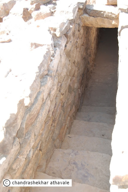
Breathing holes

Steps to enter drainage system
In the
northeast corner of the citadel a well was discovered Arrangements
were in place to draw out water from this well by using a leather bag
attached to a rope, pulled up by bullocks. A horizontal slab of the
trough have markings showing the passage of the rope used to draw
water from the wall. (This kind of arrangement was in use in India
even 40 or 50 years ago.)Water drawn from the well was conducted
through a covered channel to feed a nearby tank (4.35 meters X 2.95
meters and with a depth of 3.58 meters. Side walls of the tank were
formed by vertically placed stone slabs; the upper part had
stone-rubble masonry. The floor was also found to be paved with stone
slabs.

Well in citadel

Markings of water drawing rope rubbing against stone slab

Water inlet duct of the tank, where well water was stored
Dholavira
had a well laid out, sewage removal system with toilets, sullage
jars (waste water pots) outside many houses, sanitary pits. Drains
show a good variety even included cut-stone ones and pottery pipes.

Terracotta water pipe used for sewage removal

Sewage removal duct in a corner of the house

A broken Sullage jar for waste water in a house corner
In my
opinion, Dholavira's water supply, rain water harvesting and sewage
removal systems are such that even today, many Indian towns would be
envious of these. I find it quite difficult to describe these in
details and feel that they can be appreciated in the real sense only
after a visit.

From
the ruins of the structures found at Dholavira and discovery of
thousands of articles of daily use, pots, jewelery, weapons and the
water management system, details of which we saw earlier, it would
become quite clear to anyone that the Indus-Sarswati civilization was
an intellectually advanced society with advanced levels of knowledge
of natural phenomenon around them. Dholavira, which was part of this
civilization, was a port city, from where, regular sailings of ships
to inland cities in Sarswati and Indus basins as well as to Ports in
Mesopotamia took place. This is not possible without possessing
calendrical information such as time of the day, time of the night,
seasons, years and possibly even longer periods, and understanding
the movement of the heavenly objects such as stars, Sun and Moon for
navigational purposes. They also needed to have precise information
about the sea tides.

Dholavira
layout
During
my visit to Dholavira, I had posed this question to our guide, who
was kind enough to give some information about the way, basic
calendrical information was maintained by the Dholavira people.
According to him, certain stair cases in the Citadel ruins, were
found to have 7, 15 and 30 steps. It was easily possible, by using
markers, which probably were shifted every day, to know what day of
the week or fortnight or month that day was. By using similar
methods, it was possible to know the month. This information was
quite useful, but to have precise information about sea tides and
seasons, they still had to have some means by which they must have
related their basic calender of steps with seasonal marks like summer
and winter solstice days. How they did it, probably would have
remained a mystery for ever, but for a chance discovery of two
circular structures, by two scientists: Mr. M N Vahia from the Tata
Institute of Fundamental Research (TIFR), Mumbai and Mr. Srikumar
Menon from Manipal School of Architecture and Planning (Karnataka).

A
group of of scientists now say that this discovery is the first
identification of a structure used for observational astronomy during
the Harappan Civilisation or in other words, these two circular
structures was a functional astronomical observatory, with help of
which, Dholavira people were able identify days of solar calender
such as summer and winter solstice and use that information to
conduct business, farming and other activities.

(Image may be copyrighted)
We have seen earlier that in the southeastern corner of the Dholavira city, an administrative centre of the city (named as citadel), existed within massive ramparts or walls. This citadel had two sections: castle, where residence and administrative quarters of the chief or king were located and a Bailey, where all support activities took place. M/S Vahia and Menon found ruins of a strange looking structure in this Bailey. They describe this structure in these words and I quote.
“ In
the Bailey region of the city is a structure with a plan-form that is
markedly different from the rest of the structures in the city and
from Harappan plan-forms in general. It consists of the plinth and
the foundations of what was probably a 13-room rectangular structure,
of which two are circular rooms embedded within. It is located west
of the Citadel and is near the edge of the terrace forming the Bailey
with a drop in the west. The flat featureless horizons to the north,
west and south are visible without any obstruction, while to the east
the mound of the citadel obscures the horizon to a large extent. The
ground slopes down to the south, where one of the artificial water
reservoirs is located which would have permitted a clear view of the
southern horizon.”
The
authors add further:
“While
structures of the Harappan civilisation do not have stone pathways
leading to the entrance, these two buildings have such pathways. The
whole city is inclined 6 degrees to the West of north, but the two
circular structures in the Bailey have openings that are exactly to
the north and west respectively. In addition, the west-facing
structure has two walls that are so constructed that their shadow
would just touch the entrance to the structure on winter and summer
solstice days.”
According
to these two scientists, the the
circular structures, out of this complex 13 room structure, were
designed for non-residential purposes. The exact purpose of these
round structures was to find precisely the days of summer and winter
solstice. Before we can understand, how these structures were used by
Dholavira people, let us first note some interesting facts. The city
of Dholavira is on the Tropic of Cancer (latitude 23d 26' 22''). The
location of this structure is latitude 23d 53' 14.0'' N; 70d 12'
44.5''. However the earth’s axis of rotation fluctuates by about
0.5d over centuries and hence, we can assume that Dholavira lay
exactly on the Tropic of Cancer. Hence the shadows of all the
structures would be to the north of the structure on all days except
for the local solar noon of Summer Solstice, when the Sun would come
to the zenith and no shadows would be cast.
These
two circular structures probably had a flat roof with an circular
opening. Authors say that a bright spot of light would fall on the
floor along with its shadow. By interpreting this image and shadow,
Dholavira people could exactly find out the days of summer and winter
solstice and using their staircase calender, would know about the
month, phase of the moon and the day.

(image may be copyrighted)
The
second important information that would have been required was the
precise knowledge of the directions, without which sailings would
have been impossible. Since there were no magnetic compasses those
days ( magnetic compass was discovered only around 200-300 BCE) they
had to depend for directions on stars or in particular the Polar
star. Due to precession of the equinoxes,around 2000 BCE, the polar
star was a weak star identified as “Thuban” today.
The
authors observe:
“ Unlike
all other regions, the Bailey area rises from South to North with an
estimated inclination of 23.5d which corresponds to the latitude of
the place. Hence standing at the southern end of the Bailey, the
celestial North Pole would be seen at the top of the slope.
At
the southern end of the Bailey structure are two deep square pits
with no steps for entry which would be ideal to observe stars close
to the azimuth even in the presence of light pollution, some amount
of which would have existed even in those times.”
It
would be clear that if an observer stood in one of the pits at night
and looked towards north along the north-south slope of the ground in
Bailey, he would have always seen “Thuban,” and would have known
the true north direction on any night.
All
the readers would agree that possibility of an astronomical
observatory in Dholavira, as conceptualized by these two scientists,
is absolutely an exciting and fascinating facet of this civilization
and only shows how vibrant this civilization really was.
IV

In
this last part of the series I want to highlight certain aspects of
the life of Dholavira residents, commonly called as Harappans.
Obviously this is not an exclusive list but a few of the features of
the life of these people , that I have found not only interesting but
sometimes intriguing.

Dholavira's
geometry
Dholavira
founders, like all other Harappans from other cities and habitats,
were extremely orderly and systematic. The layout of the towns or
buildings, built with mathematical precision, are a testimony for
this. Michel Danino is a France born scientist, now settled in
India. He has carried out extensive research about geometrical ratios
found in Dholavira. In his paper “ The Metrology behind Harappan
Town Planning,” he says that all sub areas of Dholavira metropolis
were laid out such that their lengths and breadths were in a ratio of
two integer numbers such as 5:4 or 7:6. Here are some of the ratios.
Dimension
|
Ratio
|
Entire City
|
5 to 4
|
Castle (Inner
dimensions)
|
5 to 4
|
Castle (Outer
dimensions)
|
5 to 4
|
Bailey
|
1 to 1
|
Middle town
|
7to 6
|
Ceremonial ground
|
6 to 1
|
Castle's outer to
inner lengths
|
4 to 3
|
Danino
says that these ratios match exactly the ratios found in various
other mature Harappan sites such as Mohenjo-Daro, Harappa, Lothal and
Surkotada. Even the directions along which layouts were planned were
usually along the cardinal directions. Danino points out that “
Harappan architects and builders did not believe in haphazard
constructions, but followed precise canons of aesthetics based on
specific proportions.” I feel that existence of some sort of
architectural or builder''s standards can not be ruled out.
Dholavira
Cemeteries
Dholavira residents disposed off
their dead in an area that lies to the west of the citadel, in
between the bailey and the sea coast. (now Rann coast) However there
is no fixed pattern of the graves as Harappans had a composite
society having different ethnic / tribal communities following their
own practices. In the cemetery there were cist burials that
included simple cists ( a small stone-built coffin-like box), a cist
in a cairn ( a man made pile of stones) circle, a circle or a
half-circle containing several graves. In addition Archaeological
survey of India also found seven hemispherical constructions two of
which were subjected to excavations. These were huge mud brick
structures, having a circular plan and hemispherical elevation. While
one was designed in the form of a spoked wheel, the other was without
spokes. Both the structures were made over rock-cut chambers of large
dimensions.

Spoked wheel graves at Dholavira
(Image courtsey ASI)
Image may be copyrighted
Surprisingly, none of the graves or
cists had any skeletons indicating that these graves were symbolic.
or were memorial graves. ASI found that the graves were furnished
with grave goods mainly in the form of pottery. One of the
hemispherical structures yielded a necklace of steatite beads strung
in a copper wire with a hook at either end, a gold bangle, beads in
gold foil and other beads, besides specially made pottery. It is not
known, how the dead were actually disposed off, whether these were
cremated or were given a sea burial. ASI's R.S. Bisht has made an
interesting comment. He says.
“
The
hemispherical structures remind one of early Buddhist stupas. The
kind of design that is of spoked wheel and unspoked wheel also remind
one of the Sara-rata-chakra-citi and sapradhi-rata-chakra-citi
mentioned in the Śatapatha Brahmana and Sulba-sutras (Later Vedic
texts).”
Dholavira's
cultural activities
A city needed open spaces for
community gathering on festive or special occasions, royal
ceremonies, sports and entertainment and commercial activities during
trading season. Dholavira being a port city, arrival of a ship would
be an important event in the life of the city, when merchandise
brought by the ship would be on sale. Dholavira planners had planned
for this need.

Stadium Viewed from north gate
A huge open area measuring measured
283 m E-W and 45 to 47m N.S (ratio 6:1) was excavated by ASI. This
open area, lying between citadel and middle town, was closed from
all sides and entry to it was provided through two major gates, one
each on east and west. It was also furnished with tiered, stepped or
sloping stands on all four sides for spectators to sit and watch the
events going on in the open ground. ASI names it as great stadium.
Archaeologist R S Bisht says, "We found a multipurpose open
field which must have been used for everything, from sports like
wrestling and bullock cart races, to plays. Of course, plays in those
days were not the same as today. They were more like a joyous
procession with a variety of performances, including skits and dances
happening at the same time.” He adds; "The stands had gates
with stones that look worn out, as if bullock cart after bullock cart
had passed over it. The stadium was a very popular part of the
Dholavira settlement." A small portion of this field was
excavated by ASI. They found row after row of peg holes, which may
have been used to erect temporary stalls and dividers during
performances. This excavation also revealed that the field was
scattered with hundreds of jewellery beads. Mr. Bisht says, "You
can imagine performers decked in beads from top to bottom, freely
dancing and the beads falling everywhere.”
There was another smaller stadium
called the little stadium abutting the castle in north-western corner
that was separated from the great stadium by a massive stand from,
but was connected to it through an opening. For what functions,
this smaller stadium was used, remains unknown, but one can speculate
that that this might have been the green room where performers
dressed up before walking onto the main stage or it could also have
been used for exclusive shows for the royalty of the time.
Yadubirsingh
Rawat, director of Gujarat government's department of archaeology who
was part of Bisht's original team, says, "You can call the field
'rangbhoomi' or arena or stadium. We found steps around it which were
used as stands for the audience. Also, they seemed to be adding a new
layer of mud to the field every year. The mud was imported from
outside Dholavira." This layering gave the stage unique
acoustics and sonorous quality.
Dholavira's
religion
Dholavira people, like other Harappa
people, were idol worshipers. They worshiped a female figurine as a
symbol of Fertility. A male figurine also has been found. A Phallic
symbol in form of a Lingam also has been found at Dholavira.

A Lingam

A male figurine

A figurine of a pregnant female

A female figurine
Dholavira's
lifestyle
Dholavira excavations have brought
to light thousands of artifacts, which give us a fair idea about the
life style of these people. The main weapon of these people appears
to be bow and arrow, though some copper axes and hammers also have
been found. Necklaces of beads made from semi precious stones,
shells, have been found. Women wore rings on their ankles as well as
forearms. Cooking was done in terracotta pots and bronze utensils,
surprisingly with designs still being used in Indian kitchens. This
is also true for the food grinders made from stone. Weights and
measures made from quartz, sling balls from stone and extremely
beautiful lamp holders and gold ornaments, the list is endless.

Copper objects

Kitchen Utensils

Terracotta lights


A Copper mirror
(photo curtsey ASI)
(Image may be copyrighted)
I now come to the end of this
series, I have tried to describe some of the major features of this
pre-historic civilization that amazed me, but I am quite aware that I
have just skimmed the surface. I would suggest to anyone interested,
to read more from excellent books and reports published by ASI
archaeologists.
--------
I went there and left completely off beam, the reality of the place stood apart from me as if I were experiencing a surrealistic world, beyond whatever I had imagined from all my reading. There I saw a man of immense bearing, a completely composed person, with a neatly trimmed beard, in a white knee length dhoti and a pristine white shawl draped across his chest, walking past me,down the slope and into the world beyond.
ReplyDeleteSarathkannur
DeleteThanks for your response. It is true that breathtaking discoveries like Dholavira make an profound impact on visitors that can not be described in words.